Evaluating Kolmogorov-Arnold Networks for Multispectral Land Cover Classification Using Sentinel-2 Imagery in Jambi City
Article Sidebar
Main Article Content
Abstract
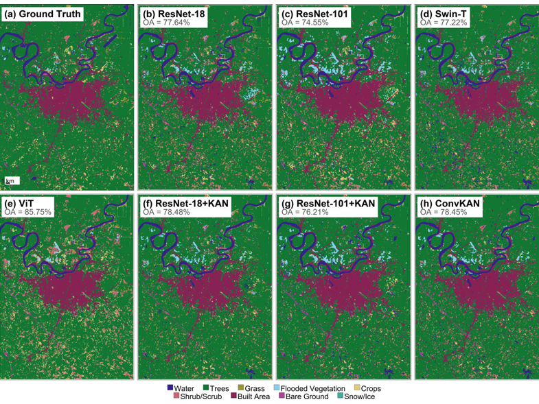
Land cover maps obtained from satellite imagery are used in environmental management and spatial planning. Deep learning now outperforms traditional machine learning for this task, but Kolmogorov-Arnold Networks (KAN) have rarely been tested on multispectral remote sensing data. This paper evaluates two KAN strategies for classifying nine land cover types from Sentinel-2 imagery in Jambi, Indonesia. ResNet-KAN adds a KAN-based classifier head to a standard CNN backbone, while ConvKAN builds the entire network from KAN-based convolution layers. Both are compared against seven CNN, Transformer, and machine learning baselines using 23 spectral features with Google Dynamic World labels as reference, and ablation experiments test spectral feature composition, ImageNet transfer learning, and input patch size. Swin Transformer reaches the highest overall accuracy (88.34%), but ConvKAN better separates rare land cover classes like Grass and Shrub, achieving the best F1-Macro (0.5870) with only 2.91 million parameters, 89.4% fewer than Swin-T. Adding spectral indices raises ConvKAN F1-Macro by 13.8%, but lowers ViT accuracy by 3.19% OA because self-attention can already learn band-ratio operations from raw bands. KAN models also perform better when trained from scratch, because most Sentinel-2 channels fall outside the visible spectrum that ImageNet covers. Spatially, ConvKAN produces maps as clean as Swin Transformer despite being ten times smaller. KAN can therefore match larger models in accuracy and map quality for multispectral land cover classification.
Article Details

This work is licensed under a Creative Commons Attribution-NonCommercial-ShareAlike 4.0 International License.
References
S. Zhao, K. Tu, S. Ye, H. Tang, Y. Hu, and C. Xie, “Land Use and Land Cover Classification Meets Deep Learning: A Review,” Sensors, vol. 23, no. 21, p. 8966, 2023, doi: 10.3390/s23218966.
D. Phiri, M. Simwanda, S. Salekin, V. R. Nyirenda, Y. Murayama, and M. Ranagalage, “Sentinel-2 Data for Land Cover/Use Mapping: A Review,” Remote Sens. (Basel)., vol. 12, no. 14, p. 2291, 2020, doi: 10.3390/rs12142291.
D. Montero, C. Aybar, M. D. Mahecha, F. Martinuzzi, M. Söchting, and S. Wieneke, “A standardized catalogue of spectral indices to advance the use of remote sensing in Earth system research,” Sci. Data, vol. 10, p. 197, 2023, doi: 10.1038/s41597-023-02096-0.
S. Talukdar, P. Singha, S. Mahato, Shahfahad, S. Pal, Y. A. Liou, and A. Rahman, “Land-Use Land-Cover Classification by Machine Learning Classifiers for Satellite Observations—A Review,” Remote Sens. (Basel)., vol. 12, no. 7, p. 1135, 2020, doi: 10.3390/rs12071135.
G. Ke, Q. Meng, T. Finley, T. Wang, W. Chen, W. Ma, Q. Ye, and T. Y. Liu, “LightGBM: A Highly Efficient Gradient Boosting Decision Tree,” in Advances in Neural Information Processing Systems (NeurIPS), 2017, pp. 3149–3157.
A. Vali, S. Comai, and M. Matteucci, “Deep Learning for Land Use and Land Cover Classification Based on Hyperspectral and Multispectral Earth Observation Data: A Review,” Remote Sens. (Basel)., vol. 12, no. 15, p. 2495, 2020, doi: 10.3390/rs12152495.
T. Boston, A. Van Dijk, and R. Thackway, “Convolutional Neural Network Shows Greater Spatial and Temporal Stability in Multi-Annual Land Cover Mapping Than Pixel-Based Methods,” Remote Sens. (Basel)., vol. 15, no. 8, p. 2132, 2023, doi: 10.3390/rs15082132.
Q. Yuan, H. Shen, T. Li, Z. Li, S. Li, Y. Jiang, H. Xu, W. Tan, Q. Yang, J. Wang, J. Gao, and L. Zhang, “Deep learning in environmental remote sensing: Achievements and challenges,” Remote Sens. Environ., vol. 241, p. 111716, 2020, doi: 10.1016/j.rse.2020.111716.
T. Kattenborn, J. Leitloff, F. Schiefer, and S. Hinz, “Review on Convolutional Neural Networks (CNN) in vegetation remote sensing,” ISPRS Journal of Photogrammetry and Remote Sensing, vol. 173, pp. 24–49, 2021, doi: 10.1016/j.isprsjprs.2020.12.010.
A. Dosovitskiy, L. Beyer, A. Kolesnikov, D. Weissenborn, X. Zhai, T. Unterthiner, M. Dehghani, M. Minderer, G. Heigold, S. Gelly, J. Uszkoreit, and N. Houlsby, “An Image is Worth 16x16 Words: Transformers for Image Recognition at Scale,” arXiv preprint arXiv:2010.11929, 2021.
Y. Bazi, L. Bashmal, M. M. Al Rahhal, R. Al Dayil, and N. Al Ajlan, “Vision Transformers for Remote Sensing Image Classification,” Remote Sens. (Basel)., vol. 13, no. 3, p. 516, 2021, doi: 10.3390/rs13030516.
Z. Liu, Y. Lin, Y. Cao, H. Hu, Y. Wei, Z. Zhang, S. Lin, and B. Guo, “Swin Transformer: Hierarchical Vision Transformer using Shifted Windows,” in Proceedings of the IEEE/CVF International Conference on Computer Vision (ICCV), 2021, pp. 10012–10022. doi: 10.1109/ICCV48922.2021.00986.
A. A. Aleissaee, A. Kumar, R. M. Anwer, S. Khan, H. Cholakkal, G. S. Xia, and F. S. Khan, “Transformers in Remote Sensing: A Survey,” Remote Sens. (Basel)., vol. 15, no. 7, p. 1860, 2023, doi: 10.3390/rs15071860.
R. Naushad, T. Kaur, and E. Ghaderpour, “Deep Transfer Learning for Land Use and Land Cover Classification: A Comparative Study,” Sensors, vol. 21, no. 23, p. 8083, 2021, doi: 10.3390/s21238083.
R. Sugumar and D. Suganya, “Satellite imagery for land cover classification using machine learning techniques,” Multimed. Tools Appl., pp. 1–26, 2025, doi: 10.1007/S11042-025-20928-6.
L. Ma, Y. Liu, X. Zhang, Y. Ye, G. Yin, and B. A. Johnson, “Deep learning in remote sensing applications: A meta-analysis and review,” ISPRS Journal of Photogrammetry and Remote Sensing, vol. 152, pp. 166–177, 2019, doi: 10.1016/j.isprsjprs.2019.04.015.
X. X. Zhu, D. Tuia, L. Mou, G. S. Xia, L. Zhang, F. Xu, and F. Fraundorfer, “Deep Learning in Remote Sensing: A Comprehensive Review and List of Resources,” IEEE Geosci. Remote Sens. Mag., vol. 5, no. 4, pp. 8–36, 2017, doi: 10.1109/MGRS.2017.2762307.
Z. Liu, Y. Wang, S. Vaidya, F. Ruehle, J. Halverson, M. Soljacic, T. Y. Hou, and M. Tegmark, “KAN: Kolmogorov-Arnold Networks,” arXiv preprint arXiv:2404.19756, 2024, doi: 10.48550/arXiv.2404.19756.
A. D. Bodner, A. S. Tepsich, J. N. Spolski, and S. Pourteau, “Convolutional Kolmogorov-Arnold Networks,” arXiv preprint arXiv:2406.13155, 2024.
M. Cheon, “Kolmogorov-Arnold Network for Satellite Image Classification in Remote Sensing,” arXiv preprint arXiv:2406.00600, 2024, doi: 10.48550/arXiv.2406.00600.
N. Firsov, V. Lobanov, E. Myasnikov, R. Khabibullin, and A. Nikonorov, “HyperKAN: Kolmogorov-Arnold Networks Make Hyperspectral Image Classifiers Smarter,” Sensors, vol. 24, no. 23, p. 7683, 2024, doi: 10.3390/s24237683.
A. Jamali, S. K. Roy, D. Hong, B. Lu, and P. Ghamisi, “How to Learn More? Exploring Kolmogorov-Arnold Networks for Hyperspectral Image Classification,” Remote Sens. (Basel)., vol. 16, no. 21, p. 4015, 2024, doi: 10.3390/rs16214015.
Y. Wang, X. Yu, Y. Gao, J. Sha, J. Wang, S. Yan, K. Qin, Y. Zhang, and L. Gao, “SpectralKAN: Weighted Activation Distribution Kolmogorov–Arnold Network for Hyperspectral Image Change Detection,” Pattern Recognit., vol. 175, p. 113042, 2026, doi: https://doi.org/10.1016/j.patcog.2026.113042.
E. Rustiadi, A. E. Pravitasari, R. A. Priatama, J. Siregar, J. Junaidi, Z. Zulgani, and R. I. Sholihah, “Regional Development, Rural Transformation, and Land Use/Cover Changes in a Fast-Growing Oil Palm Region: The Case of Jambi Province, Indonesia,” Land (Basel)., vol. 12, no. 5, p. 1059, 2023, doi: 10.3390/land12051059.
I. L. Sari, C. J. Weston, G. J. Newnham, and L. Volkova, “Developing Multi-Source Indices to Discriminate between Native Tropical Forests, Oil Palm and Rubber Plantations in Indonesia,” Remote Sens. (Basel)., vol. 14, no. 1, p. 3, 2022, doi: 10.3390/rs14010003.
H. Tamiminia, B. Salehi, M. Mahdianpari, L. Quackenbush, S. Adeli, and B. Brisco, “Google Earth Engine for geo-big data applications: A meta-analysis and systematic review,” ISPRS Journal of Photogrammetry and Remote Sensing, vol. 164, pp. 152–170, 2020, doi: 10.1016/j.isprsjprs.2020.04.001.
K. Karra, C. Kontgis, Z. Statman-Weil, J. C. Mazzariello, M. Mathis, and S. P. Brumby, “Global land use/land cover with Sentinel-2 and deep learning,” IEEE International Geoscience and Remote Sensing Symposium (IGARSS), pp. 4704–4707, 2021, doi: 10.1109/IGARSS47720.2021.9553499.
C. F. Brown, S. P. Brumby, B. G. Williams, T. Birch, S. B. Hyde, J. Mazzariello, W. Czerwinski, V. J. Pasquarella, R. Haertel, S. Ilyushchenko, K. Schwehr, M. Weisse, F. Stolle, C. Hanson, O. Guinan, R. Moore, and A. M. Tait, “Dynamic World, Near real-time global 10 m land use land cover mapping,” Sci. Data, vol. 9, p. 251, 2022, doi: 10.1038/s41597-022-01307-4.
A. E. Maxwell, T. A. Warner, and L. A. Guillén, “Accuracy Assessment in Convolutional Neural Network-Based Deep Learning Remote Sensing Studies—Part 1: Literature Review,” Remote Sens. (Basel)., vol. 13, no. 13, p. 2450, 2021, doi: 10.3390/rs13132450.
G. M. Foody, “Explaining the unsuitability of the kappa coefficient in the assessment and comparison of the accuracy of thematic maps obtained by image classification,” Remote Sens. Environ., vol. 239, p. 111630, 2020, doi: 10.1016/j.rse.2019.111630.
S. Farhadpour, T. A. Warner, and A. E. Maxwell, “Selecting and Interpreting Multiclass Loss and Accuracy Assessment Metrics for Classifications with Class Imbalance: Guidance and Best Practices,” Remote Sens. (Basel)., vol. 16, no. 3, p. 533, 2024, doi: 10.3390/rs16030533.
M. Fawzy and Á. Barsi, “VHR Multispectral Satellite Image Classification with Kolmogorov-Arnold Networks for Urban Applications,” ISPRS Annals of the Photogrammetry, Remote Sensing and Spatial Information Sciences, vol. X-G-2025, pp. 245–252, 2025, doi: 10.5194/isprs-annals-X-G-2025-245-2025.